Understanding the Role of Deep Learning in Analyzing the Long-Term Effects of Coal Mining
In recent years, deep learning techniques, especially Convolutional Neural Networks (CNNs), have revolutionized the field of remote sensing and geospatial analysis, providing highly accurate methods for classifying and interpreting satellite imagery. One exciting application of CNNs is in the field of land-use change detection, particularly in areas impacted by human activities such as coal mining. The study on the long-term impacts of coal mining in Jharia Coalfield (JCF) showcases how transfer learning and deep CNN models can be leveraged to analyze time-series satellite data and track changes in land-use (LU) patterns over several decades.
This blog delves into the methodology and findings of the study, which uses transfer learning to apply deep CNNs for classifying land-use patterns in satellite imagery spanning from 1987 to 2021. The research analyzes the effects of coal mining activities on land-use types like barren land, built-up areas, vegetation, coal mining regions, and waterbodies, providing valuable insights into the environmental changes caused by industrialization in Jharia Coalfield.
What is Transfer Learning and Deep CNN?
Transfer Learning is a machine learning technique where a model developed for a particular task is reused as the starting point for a model on a second task. The idea is that the pre-trained model, which has already learned valuable features from a large dataset, can be fine-tuned on a smaller dataset for a related task. This approach is particularly beneficial when limited labeled data is available, as it helps to achieve high performance without starting from scratch.
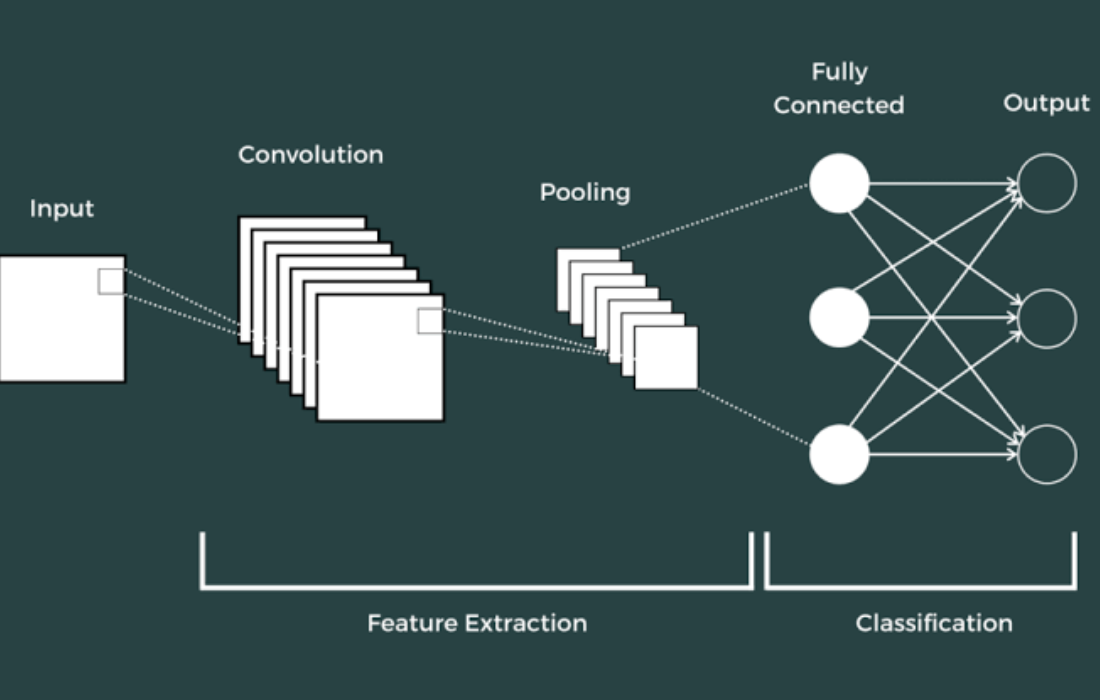
Convolutional Neural Networks (CNNs) are deep learning models specifically designed for processing grid-like data, such as images. In the context of satellite imagery, CNNs can automatically learn spatial hierarchies of features (edges, textures, shapes) and classify the image into different categories (e.g., barren land, built-up areas, etc.).
Study Overview: Analyzing Land-Use Changes in Jharia Coalfield
The study’s primary aim was to analyze the long-term impact of coal mining activities on land-use patterns in Jharia Coalfield (JCF), located in Jharkhand, India. The region is notorious for its coal mining activities, which have led to significant environmental degradation, including deforestation, air pollution, and the creation of barren land.
To train and validate the model, the researchers created a new database using Landsat satellite imagery from 1987 to 2021, spanning a 34-year period. The data was extracted at 2-year intervals, allowing the researchers to observe changes in land-use patterns over time. The database consisted of 10,000 image samples of 6×6 size, categorized into five land-use types:
- Barren land
- Built-up area
- Coal mining region
- Vegetation
- Waterbody
The CNN model was then trained using these images, and transfer learning was applied to enhance the accuracy of classification, given the limited availability of labeled training data.
Methodology: Transfer Learning and Deep CNN
The researchers used transfer learning with a pre-trained deep CNN model. This approach enabled them to apply a model trained on a large and diverse dataset, such as ImageNet or Landsat data from other regions, and fine-tune it with the specific satellite data from the Jharia region.
The process of applying transfer learning for land-use classification typically follows these steps:
- Data Preprocessing: The satellite images were resized into smaller 6×6 patches for efficient training. Data augmentation techniques were also applied to increase the diversity of the training data.
- Model Selection: The researchers selected a deep CNN architecture, which is capable of handling complex spatial relationships in satellite images. The pre-trained model was chosen for its ability to learn low-level features such as edges, textures, and shapes, which are essential for classifying land-use types.
- Fine-Tuning: The pre-trained CNN model was fine-tuned using the Jharia-specific dataset. During fine-tuning, the weights of the final layers were adjusted to improve the model’s performance on the specific land-use categories in the JCF dataset.
- Training and Validation: The model was trained on the training dataset (10,000 samples), and its performance was evaluated on the validation dataset. The accuracy of classification was measured to ensure that the model generalizes well to unseen data.
Key Findings and Results
The study demonstrated that the transfer learning approach using deep CNNs for land-use classification achieved impressive results, with accuracy levels of:
- 95
- 88
These results indicate that the deep CNN model was highly effective at classifying land-use types, even with a relatively small dataset for training. The accuracy is a testament to the power of transfer learning, which allowed the model to leverage pre-learned features and adapt them to the specific characteristics of Jharia Coalfield.
Changes in Land-Use Patterns (1987–2021)
The analysis revealed significant changes in the land-use patterns of the Jharia Coalfield over the past three decades. The results showed:
- Barren land: Decreased from 237.30 sq. km (39.88
- Coal mining regions: Decreased from 118.77 sq. km (19.96
- Waterbodies: Decreased from 35.58 sq. km (5.98
- Coal mining regions: Decreased from 118.77 sq. km (19.96
On the other hand, areas of built-up land and vegetation showed notable growth:
- Built-up area: Increased from 120.14 sq. km (20.19
- Vegetation: Increased from 83.19 sq. km (13.98
Time-Series Correlation Analysis
The time-series analysis of the land-use data indicated that coal mining was the most sensitive land-use type, showing significant fluctuations in its area over the years. Barren land showed the least sensitivity until 2011, after which vegetation became the least sensitive land-use type.
These results suggest that coal mining activities have had a lasting impact on the land-use dynamics of the region, significantly altering the landscape. The decrease in barren land and coal mining regions over time reflects reclamation efforts or natural changes, while the increase in built-up areas and vegetation indicates urbanization and efforts towards environmental restoration.
Conclusion
This study demonstrates the effectiveness of transfer learning using deep CNN models for classifying time-series satellite images, providing valuable insights into the long-term impacts of coal mining on land-use patterns in the Jharia Coalfield. The ability of deep learning models to analyze and detect subtle changes in satellite imagery over long periods of time is a powerful tool for assessing environmental degradation and guiding sustainable development strategies.


